Guide
Cut and Fill Explained for Estimators
How cut and fill volumes are found, and how bank, loose and compacted yards, shrink and swell decide whether a site imports or exports.
By IntelCost Team · · 8 min read
Cut and fill is the earthwork at the heart of most site bids. Wherever the ground has to come down, you cut. Wherever it has to go up, you fill. The volumes look like one subtraction, but the number you price depends on more than that: which grade is which, how the volume was measured, what state the soil is in when you count it, and what happens to the topsoil and the bad soil under the building. This guide explains each piece in plain terms, with worked examples you can check by hand.
Existing grade and finished grade
Every cut and fill calculation compares two surfaces:
- Existing grade (EG): the ground as it is today, from the topographic survey.
- Finished grade (FG), also called proposed grade: the ground as the civil engineer designed it, from the grading plan.
Where finished grade is below existing grade, the difference is cut. Where finished grade is above existing grade, the difference is fill. The line where the two cross is the cut/fill line, or zero line, with no cut and no fill.
On the drawings, existing grade is usually shown as dashed contours and existing spot elevations on the survey. Finished grade is shown as solid contours, proposed spot elevations, finished floor elevations and curb or pavement elevations on the grading plan. Before measuring anything, check that both sheets use the same vertical datum and benchmark. A survey and a grading plan a foot apart in datum will give you a site that looks like all cut or all fill.
How cut and fill volumes are calculated
There are three common methods. They all do the same thing: find the depth between the two surfaces at many places and add up the volume.
The grid method
Lay a grid over the site, read existing and finished elevations at each grid corner, and take the cut or fill depth at each corner. Each grid square's volume is its area times the average depth of its four corners.
Worked example. Say one grid square is 50 ft x 50 ft and the cut depths at its corners are 1.2 ft, 1.6 ft, 2.0 ft and 1.4 ft.
| Step | Calculation | Result |
|---|---|---|
| Square area | 50 ft x 50 ft | 2,500 SF |
| Average depth | (1.2 + 1.6 + 2.0 + 1.4) ft / 4 | 1.55 ft |
| Volume | 2,500 SF x 1.55 ft | 3,875 CF |
| Cubic yards | 3,875 CF / 27 | 143.5 CY of cut |
Add up every square. Where a square has cut at some corners and fill at others, a plain average mixes the two, so use a smaller grid there or split the square along the zero line.
Cross sections and average end area
Common on roads, channels and long pads. Cut sections across the work at regular stations, measure the cut and fill area on each section, and take the volume between two sections as the average of their areas times the distance between them.
Worked example. Say two sections are 50 ft apart, with a cut area of 120 SF at the first and 180 SF at the second.
| Step | Calculation | Result |
|---|---|---|
| Average end area | (120 SF + 180 SF) / 2 | 150 SF |
| Volume | 150 SF x 50 ft | 7,500 CF |
| Cubic yards | 7,500 CF / 27 | 277.8 CY of cut |
The average end area method tends to overstate the volume when neighboring sections are very different in shape. Closer stations reduce that.
Surface to surface (TIN) comparison
Software usually builds each grade as a TIN surface: a triangulated irregular network made by joining the contour and spot elevation points into triangles. With an existing surface and a finished surface, the software compares them at every point inside the work boundary and adds up the volume between them, cut where finished is lower and fill where it is higher.
The math is the grid method taken to its limit, with no grid size to choose. The result is only as good as the surfaces, though. Missing spot elevations at curb lines, ridges and swales, or a contour digitized at the wrong elevation, flow straight into the volume. Look at the surface before you trust the number.
Bank, loose and compacted yards
The same soil takes up a different volume depending on its state:
- Bank cubic yards (BCY): soil in place, undisturbed. Cut volumes from the surfaces are bank yards.
- Loose cubic yards (LCY): soil after it is dug, in the bucket, the truck or a stockpile. It takes up more room because air gets in.
- Compacted cubic yards (CCY): soil placed and compacted as fill. Fill volumes from the surfaces are compacted yards.
This is why you cannot simply subtract fill from cut. A bank yard of cut does not make a compacted yard of fill, and a truck hauls loose yards, not bank yards.
Shrink and swell, with worked conversions
Swell
Swell is how much the soil grows from bank to loose. As a percentage: swell = (loose volume - bank volume) / bank volume. It depends on the material:
| Material | Typical swell, bank to loose |
|---|---|
| Sand and gravel | Roughly 10 to 15% |
| Common earth | Roughly 20 to 30% |
| Clay | Roughly 30 to 40% |
| Blasted rock | Often 50% or more |
These are rough guides only. The actual factors come from the geotechnical report or from the soil on the job; use them whenever you have them.
Worked example. Say you have 1,000 BCY to haul off, with an example swell of 25 percent and trucks carrying 12 LCY each.
- Loose volume: 1,000 BCY x 1.25 = 1,250 LCY.
- Truck loads: 1,250 LCY / 12 LCY per load = 104.2, so 105 loads.
Shrink
Shrink is the loss in volume from bank to compacted. Compacted fill is denser than the ground it came from, so it takes more than one bank yard to make one compacted yard of fill. A common range for ordinary soils is 10 to 20 percent; check your specs and your geotechnical report.
Shrink is written two ways, and the difference matters:
- As a loss from bank: compacted = bank x (1 - shrink). Bank needed = compacted / (1 - shrink).
- As extra cut the fill needs: bank needed = compacted x (1 + shrink).
Worked example. Say the site needs 3,400 CCY of fill and the shrink is 15 percent.
| Convention | Calculation | Bank yards needed |
|---|---|---|
| Loss from bank | 3,400 CCY / 0.85 | 4,000 BCY |
| Extra cut needed | 3,400 CCY x 1.15 | 3,910 BCY |
The same 15 percent gives answers 90 BCY apart. Read how the plans or the geotechnical report define it, and use their definition.
Balancing the site: import and export
Balance tells you whether the site has soil to get rid of (export) or needs soil brought in (import). Compare cut and fill in the same state, after shrink.
Worked example. Say the surfaces give 5,000 BCY of cut and 3,400 CCY of fill, with an example shrink of 15 percent (loss from bank) and swell of 25 percent.
- Bank yards the fill needs: 3,400 CCY / 0.85 = 4,000 BCY.
- Surplus: 5,000 BCY - 4,000 BCY = 1,000 BCY to export.
- Export hauled loose: 1,000 BCY x 1.25 = 1,250 LCY, or 105 loads at 12 LCY each.
Now say the fill were 4,600 CCY instead. The cut makes 5,000 BCY x 0.85 = 4,250 CCY of fill, so the site is short 4,600 CCY - 4,250 CCY = 350 CCY of placed fill. Import is often sold by the ton or the truckload, so convert the shortage to the supplier's unit using that material's own factors.
A balance that is close to zero is worth a second look. Small changes in shrink, topsoil depth or undercut can swing a balanced site into a real import or export.
Topsoil stripping
Topsoil is stripped before mass grading, and it is usually not acceptable as structural fill. It affects the balance two ways. In cut areas, the top of the cut is topsoil, so less of the cut is usable fill. In fill areas, stripping lowers the starting grade, so more fill is needed.
Worked example. Say the strip area is 300 ft x 200 ft at an example depth of 6 in.
| Step | Calculation | Result |
|---|---|---|
| Area | 300 ft x 200 ft | 60,000 SF |
| Volume | 60,000 SF x 0.5 ft | 30,000 CF |
| Bank yards | 30,000 CF / 27 | 1,111.1 BCY |
| Stockpile, at 25% swell | 1,111.1 BCY x 1.25 | 1,388.9 LCY |
If that whole area is in fill, the fill grows by the same 30,000 CF, which is another 1,111.1 CCY to place. Decide whether the topsoil is hauled off, stockpiled for respreading on lawn areas, or both, and price each.
Undercut and subgrade
Finished grade on most grading plans is the top of the finished surface: top of pavement, top of slab. Earthwork stops lower, at subgrade, under the pavement section or the slab and its base. In pavement areas, the earthwork grade is finished grade minus the section thickness.
Worked example. Say a 20,000 SF parking lot has an example section of 2 in asphalt over 8 in of aggregate base, 10 in in total.
- Section depth: 10 in / 12 = 0.833 ft.
- Volume: 20,000 SF x 10/12 ft = 16,666.7 CF.
- Cubic yards: 16,666.7 CF / 27 = 617.3 CY of extra cut (or less fill) to reach subgrade.
Undercut is digging out unsuitable soil below subgrade and replacing it with acceptable fill, usually where the geotechnical report calls for it under the building.
Worked example. Say the report calls for 2 ft of undercut under an 80 ft x 120 ft building pad.
| Step | Calculation | Result |
|---|---|---|
| Area | 80 ft x 120 ft | 9,600 SF |
| Volume | 9,600 SF x 2.0 ft | 19,200 CF |
| Undercut excavation | 19,200 CF / 27 | 711.1 BCY |
| Replacement fill | same space, compacted | 711.1 CCY |
| On-site soil for it, 15% shrink | 711.1 CCY / 0.85 | 836.6 BCY |
The unsuitable soil usually leaves the site, which adds to the export.
Doing it in takeoff software
Grid and cross section math still work, and they are the best way to check a number. For a whole site, you can build the two surfaces from the plan contours and let software compare them.
In IntelCost, the Earthwork tab builds existing and finished grade surfaces from contours and spot elevations on your PDF plans, then calculates cut, fill and net inside a work boundary. Strip Areas handle topsoil, Site Features handle pavement sections, undercut and subgrade prep, and the results become Division 31 lines in the estimate.
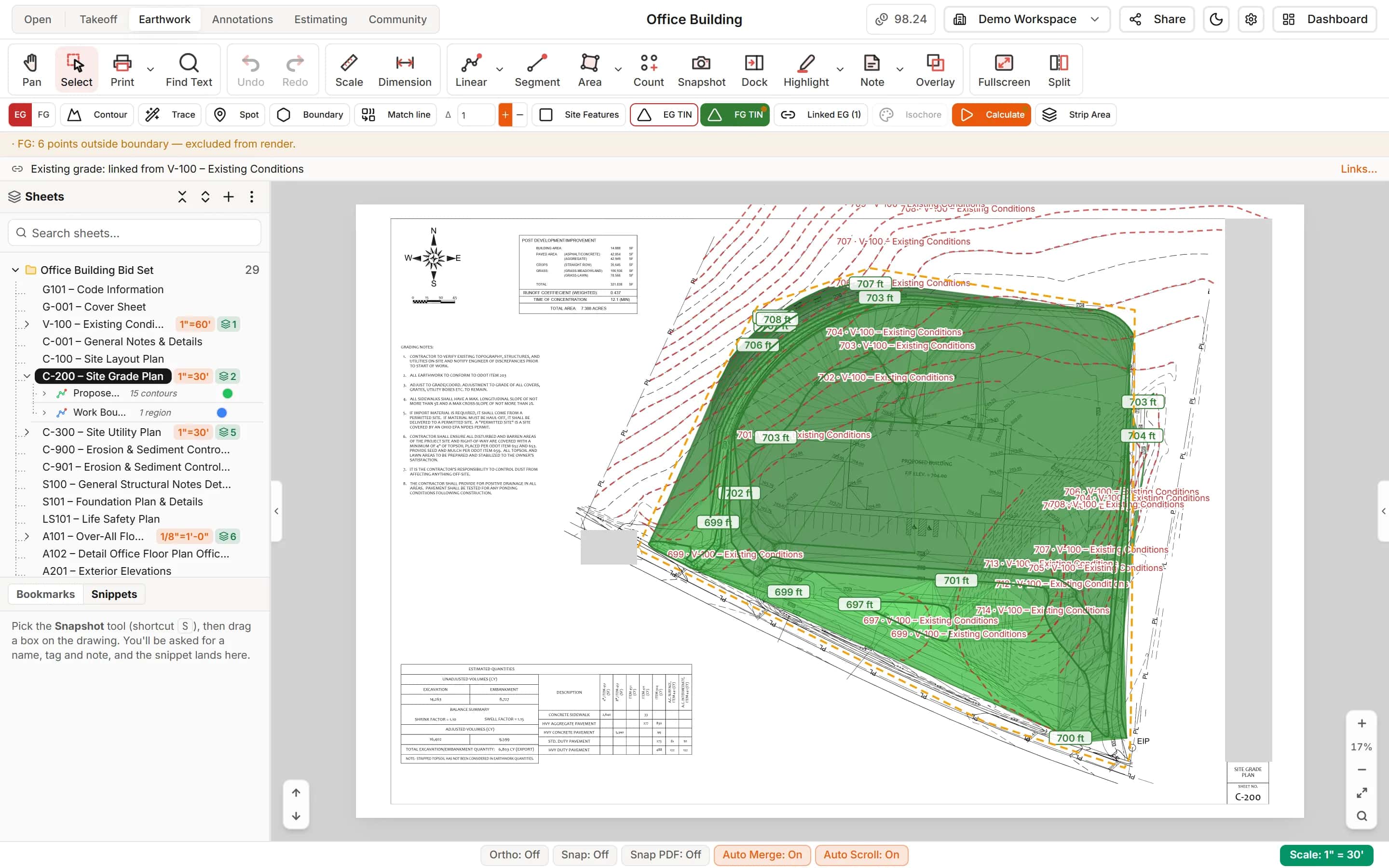
For the rest of the site scope, from clearing to paving, see sitework estimating basics.
Checklist
- Existing and finished grade on the same datum.
- Volumes measured inside a clear work boundary.
- Cut counted in bank yards, fill in compacted yards, hauling in loose yards.
- Shrink and swell from the geotechnical report, with their definition read.
- Topsoil stripping, pavement and slab sections, and undercut accounted for before the balance.
- Import or export converted to the unit you will buy or haul in.